The
City of Cincinnati and the
Hamilton County Development Company have joined together to make it easier to find available commercial development sites within their jurisdictions.
The easy-to-use interface on the
Cincinnati Commercial Site Portfolio is searchable by property type, size, jurisdiction and region.
A clickable map using
GIS Planning's ZoomProspector software reveals the site's proximity to amenities like schools, hospitals, and parks, and whether the property might be subject to tax incentives from Community Reinvestment Areas or Enterprise Zones.
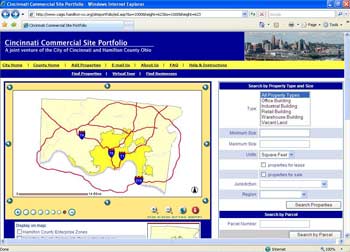
Website visitors also can create customizable reports where they can compare workforce demographics within a given radius and proprietary information on possible competitors.
Broker information and rates allow developers to negotiate for the property directly, similar to residential real estate listings.
Meg Olberding, assistant to the city manager for the City of Cincinnati, says that the city is trying to do more to promote this useful tool.
"It's a nice feature if you just want to get a snapshot of what an area's all about," she says.
Staff from the
Hamilton County Regional Planning Commission and
CAGIS also contributed to the development of the website.
Writer:
Kevin LeMaster
Source: Meg Olberding, assistant to the city manager, City of Cincinnati
Enjoy this story?
Sign up for free solutions-based reporting in your inbox each week.