Healing a Scar: Debate continues over too-wide, too-busy Liberty Street
City officials and neighborhood residents consider options to narrow Liberty Street, reconnect north and south Over-the-Rhine and calm traffic, but the almighty auto is poised to dominate as always.
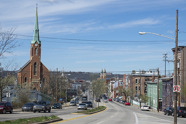
Liberty Street runs like a scar across the middle of Over-the-Rhine. But how to heal it is a source of contention as the city’s Transportation & Engineering Department considers alternatives to the present busy thoroughfare.
New residents and businesses are moving to the revived historic neighborhood, craving an urban lifestyle based around architectural restoration, reduced car use and overall sustainability. But Liberty looms as a key constraining obstacle to that vision.
With seven lanes (including two for parking and one for turns) running east-west between Central Parkway and Reading Road, it’s a wall of traffic and noise that intimidates pedestrians and cyclists. Counting the 20 feet of space allowed for sidewalks, Liberty is a 90-foot-wide visual interruption of the otherwise-dense OTR cityscape.
As a result, it psychologically as well as physically separates north from south and, so far at least, renaissance from status quo.
“If we call it a scar and can reduce it, that will help with renovation of the northern section,” says Stu Spaulding, a 25-year-old OTR resident.
Recognizing that problem, the Over-the-Rhine Brewery District Community Urban Redevelopment Corp. and others called for a Liberty Street redesign in its master plan.
“We identified Liberty as a key corridor that disconnects the south half of Over-the-Rhine from the north and hinders a lot of (northern) development because of the huge gap,” Brewery District Executive Director Steven Hampton says. “It’s still a stark line between what happens south and north.”
5 traffic lanes vs. 3
At the Brewery District’s request, in 2013 the city began looking at options for modifying Liberty from Central Parkway to Broadway, the section that cuts through Over-the-Rhine’s heart. It’s now dubbed the Liberty Street Safety Improvements Project. At the same time, the city is conducting a separate but related study to consider making Main Street two-way from 12th Street to Liberty.
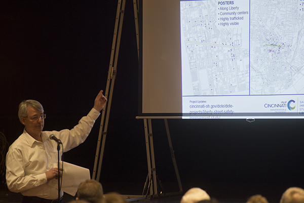
The Liberty Street Safety Improvements Project is in the planning process right now, with no money set aside for design or construction. And that process has been a slow one.
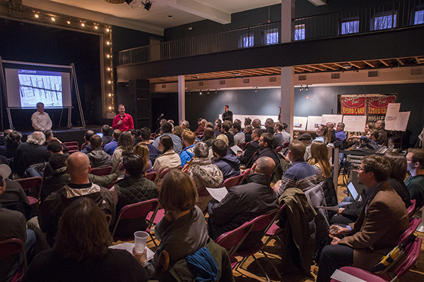
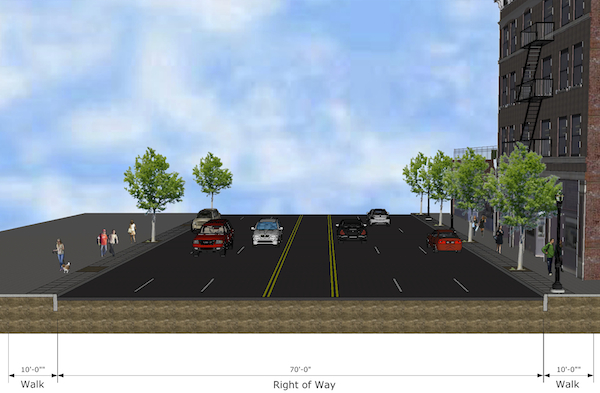
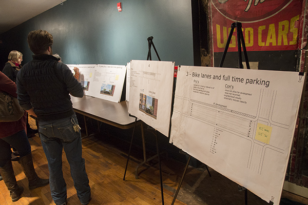
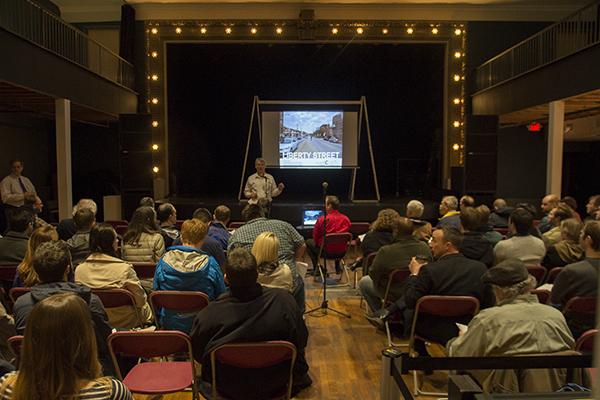
At a public meeting March 1 at Woodward Theater, Transportation and Engineering representatives presented seven “conceptual options.” It seemed clear they currently support a five-lane option, which would reduce the existing roadway width by 20 feet (to 50 feet) and return those 20 feet (and existing sidewalks) to development space.
That five-lane concept would reserve all four lanes (plus a center left-turn lane) for cars from 7 a.m. to 7 p.m. weekdays. At other times, the curb lanes could be used for parking.
The city department’s representatives left open the possibility for alterations to that basic idea. And they heard some, while also hearing support for it as an improvement over the existing Liberty Street.
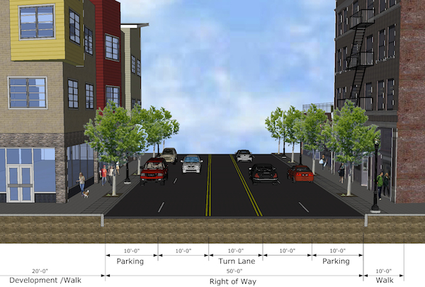
A different conceptual option — the “three-lane design” — drew plenty of support, too. That proposal envisions just one lane of moving traffic in either direction, plus a center turn lane; it would also have two curbside bike lanes buffered from two off-curb parking lanes. With all of those lanes, the overall roadway width would be 62 feet, but just 30 of it drivable — thus wider than the five-lane proposal.
Traffic and Engineering representatives pointed out that the three-lane design wouldn’t narrow Liberty enough to reconnect north and south visually, a project goal. They also felt it could cause congestion.
Putting people ahead of cars
To some attendees at the March 1 public meeting, the “drawback” of Liberty Street congestion would be a good thing. Maybe driving will be reduced in that scenario, they argued, with people instead converting to mass transit, including the new streetcar, or moving closer to work.
“We should be pushing the envelope to get away from the status quo,” neighborhood resident Charlie Hinkley says in a follow-up interview after he spoke at the March 1 meeting. “We should not expect or encourage fast-moving vehicles because eventually someone’s going to get hurt. Also, residents have to live with noise and that traffic.”
The phrase that was heard from some in the audience was “traffic evaporation,” and it’s in line with what Jeff Speck, author of Walkable City: How Downtown Can Save America, One Step at a Time, expressed in a Soapbox interview last October. He believes walkability comes at the expense of the automobile.
One of Speck’s keys to making cities more walkable is to reduce the width of streets and number of traffic lanes in areas where pedestrianism is desired. That can result in more space on the sides for bike lanes and curbside parallel parking.
“Many cities have streets with more lanes than the traffic on them demands,” Speck told Soapbox last fall. “It’s extra pavement that doesn’t do anyone any good. It just encourages speeding. And parallel parking makes streets safer because it’s a barrier of steel to protect the sidewalk from moving vehicles, and it convinces drivers to drive more slowly.”
Speck said he sees evidence that city leaders and planners are awakening to the benefits of a walkable urban core but they have a difficult time turning away from our culture’s automobile preferences.
“Unfortunately, almost everyone with the right motives is applying wrong techniques to achieve the goals,” he said. “The reason is because of the legacy of the auto age, which still controls so much of the process because it’s been fossilized into the policies, documents, zoning codes and subdivision ordinances that control what our cities have become.”
At the Woodward meeting, city traffic engineer Dennis Lechlak and acting city architect Matthew Andrews strongly hinted they wouldn’t support the three-lane option.
“We have an intersection every 200 feet,” Andrews said. “When you come into a heavy urban situation with intersections like that and driveways, it makes three lanes next to impossible.”
According to a 2012 survey by West Chester-based Kleingers & Associates, the overall range of daily traffic on Liberty Street ranges from about 15,700 to 18,200, a city spokesman said. The highest numbers are between Sycamore Street and Reading Road, where Liberty ends into ramps to and from I-471.
Even the Brewery District is wary of narrowing Liberty too much, since much of the existing traffic is trucks.
“It is a mixed-used neighborhood,” Hampton says. “Findlay Market, Moerlein, Rhinegeist need to have their traffic get in and out. We don’t want to impede upon the accessibility of any of our businesses. So are three lanes a little too restrictive? Maybe it could be.”
OTR can use a ‘road diet’
Liberty wasn’t always such a busy street. Answering questions via email, Transportation and Engineering Director Michael Moore says it was widened in 1958 because of I-75 construction.
Moore explains that old maps from 1904 to 1930 indicate that the right-of-way (property line-to-property line) was 40 feet.
“We believe the street (curb to curb) was approximately 22-24 feet wide based on photographs,” he says. “It appears that there was one travel lane in each direction.”
Liberty today continues west of Central Parkway to Dalton Street in the West End and feeds traffic to and from I-75. As part of the 1958 expansion, Liberty was also extended east from Liberty Hill to Reading Road.
What was Liberty like long ago when it was a neighborhood street? Christopher Smith, who lives downtown and attended the Woodward meeting, recalls his great-grandmother telling him about being raised in a house on Liberty near Broadway — with a wrought-iron gate and a small front yard — until it was sold in the 1930s following her parents’ death. (It was eventually demolished for the 1958 widening.)
She remembered that world fondly, he says, because it worked.
“I understand we’re not living in 1910 anymore, but I feel we’ve overbuilt our roads for the last 40-50 years,” Smith says in a follow-up interview. “Now I feel we could use a road diet. It would benefit the neighborhood. It’s uncomfortable to walk across that street now.”
Check the City of Cincinnati’s website for updates and more information on the Liberty Street Safety Improvements Project, including dates of any future public meetings.
Related Articles
Fewer options, fuller ERs: The behavioral health fallout of Medicaid cuts
MHA advocates for state funding that preserves behavioral health care and keeps rural hospitals open.

What does the new childhood vaccine schedule actually mean for your family?
Officials say not much will change. Experts aren’t so sure.

New platform to share ‘Common Ground’ from community ideas and solutions
Issue Media Group, a multilocal network of solutions-based, issues-focused digital publications, has launched a new national platform for increasing the reach and impact of its journalism.