Soapdish: 52 Card Pickup
Cincinnati is the home of 52 individual and unique neighborhoods that, some say, serve as the the "key to city's success." But how did we come to have such a rich, quilted patchwork of localities and how will these 52 different personalities work to create a charged and united region? Soapdisher turned explorer, Casey Coston takes us on a quick tour…

Several weeks ago, on these very (virtual) pages, no less a sage than City Manager, streetcar proponent and all around Cincinnati panjandrum Milton Dohoney submitted his third guest SoapBlog. In said SoapBlog, Dohoney noted that while downtown is our fair metropole’s proverbial “showpiece, the backbone of the community, and the key to the city’s success, is its neighborhoods.”
Ah yes….the neighborhoods. Remember those? Let’s turn to the map now, shall we?
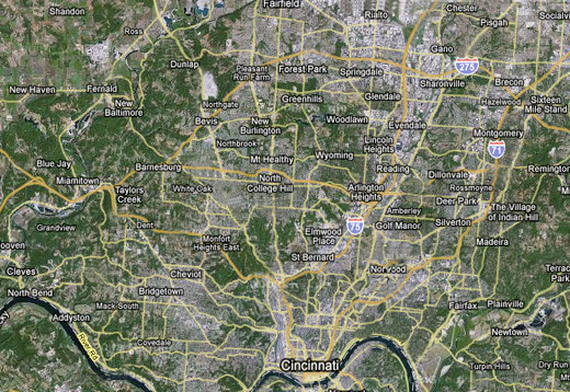 Cincinnati is a city of 52 individual neighborhoods, a meandering patchwork crazy-quilt mash-up of different sizes, shapes, allegiances and demographics, all cobbled together over the years into a most decidedly diverse and, sometimes, non-cohesive unit. Some of these neighborhoods are fairly obvious, such as the Downtown/Central Business District (including the riverfront), checking in at #42, while others may be a bit more obscure to those less familiar. I mean, all apologies to those who live there, but if someone asked me (a non-native) to point out where the neighborhoods of Millvale (#16) or Fay Apartments (#14) were on a map of Cincinnati, I would probably be stammering around like the guy in the Fed Ex commercial who can’t find China. Sedamsville(#36)? I can explain the concept of proportional representation quicker than I could tell you how to get to Sedamsville (it’s on the west side along the river, by the way, I checked).
Moreover (and this may be common sense to natives, students and/or alums), but I was unaware that the UC campus is technically located in the neighborhood known as the Heights (#23), which is surrounded by the three more commonly recognized neighborhoods of Clifton (#21), Corryville (#24) and CUF (#22, and, collectively, Clifton Heights, University Heights and Fairview).
Many of these neighborhoods developed over time as individual units, prospering, procreating and dutifully constructing their fiefdoms outside of the shadows of the urban limits of Cincinnati proper. Eventually, however, as Cincinnatus continued to thrive and fill up the relatively level basin stretching out from the river, it expanded its reach (and, naturally, its tax base), extending its borders further onward, outward and upward. Save, of course, for those island “paradise” municipalities of St. Bernard and Norwood, which (in those days at least) had their own industrial “golden geese” tax bases on which to rely in order to fill the city coffers (P&G and GM/Fisher Body respectively). As the borders of the city stretched and enveloped what were once independent-minded villages, the conquering municipality continued to rack ‘em up, ultimately plateauing at its current #52 count today.
The city embarked on its acquisition spree around 1868, at the time short-circuiting the hopes and dreams of fledgling “suburbs” who fashioned themselves as the new “place to be.” Pity, for example, the meteoric rise and fall of the Village of Woodburn–prior to 1864 it was known as East Walnut Hills, after which it then experienced a short shelf life of just seven years before falling to the Cincinnati annex machine (and reverting back to East Walnut Hills) in 1873 (and no…no, despite its ersatz “Old West outpost” appearance, The Schulhoff Tool Corral/Rental did not come into being until 1935). Alas, poor Woodburn, we hardly knew ye.
Nowadays of course, you also have a wealth and breadth of thriving hoods not just inside the city limits, but outside as well (see, e.g. Newport, Covington, Mariemont, Wyoming and Glendale, to name but a few), as well as the numerous communities points west, north and east…although that may be beyond the kin of this particular column (and my expertise as well).
Many of these neighborhoods, at one time flourishing and independent, continue to be thriving yet somewhat more inter-dependent these days. It is one of the city’s truly great attributes that it has so many vibrant neighborhoods, many of them replete with walkable commercial centers, oftentimes picturesque squares, around which bars, restaurants and retail coalesce. Many of Cincinnati’s peer cities would be thrilled to have a buzzing and livable lineup of neighborhoods such as Mt. Adams, North Avondale, Clifton, Hyde Park, Northside, Oakley, O’Bryonville, Mt. Lookout, Columbia Tusculum et al., all within the city and all within a short radius of the downtown core (10 minute drive, tops). As I have noted before, the ideal urban success model is not a doughnut, and with a continually thriving center city, the beneficial spinoff to the inner-ring neighborhoods can only increase. While, at times, the presence of 52 individual puzzle pieces can lead to a reverse-NIMBY Balkanization, it is to the credit of Cincinnati that it has been able to preserve these vital pockets while continuing to strengthen the city core as well.
And…by the by, when the Banks begins to bloom in the course of the next several years, we’ll be playing 53 card pick up. Better get a new deck.
Related Articles

Fewer options, fuller ERs: The behavioral health fallout of Medicaid cuts
MHA advocates for state funding that preserves behavioral health care and keeps rural hospitals open.

What does the new childhood vaccine schedule actually mean for your family?
Officials say not much will change. Experts aren’t so sure.

New platform to share ‘Common Ground’ from community ideas and solutions
Issue Media Group, a multilocal network of solutions-based, issues-focused digital publications, has launched a new national platform for increasing the reach and impact of its journalism.